In which The Author goes exploring again
It's only the first week of April, but I'm already planning this September's Walking Together event in aid of Anthony Nolan. After the success of the 2018 walk (see Seventeen Miles Later), in which the team from Jacs Music Venue (Paul, Rhian, Liam, Kate, Betty Boop the mini whippet – who sensibly baled out halfway through – and I) raised a staggering £660.61, I thought we'd try and keep the momentum going.

With this in mind I set out on the mid-morning bus to Penderyn on Wednesday. It's the furthest north you can get from Aberdare by bus, just inside the southern boundary of the Brecon Beacons National Park. The Lamb Hotel in the village was the starting point for last year's walk along the Cynon Trail. It's also a good location to set out for Waterfall Country.
I've blogged a few times about the spectacular and sometimes challenging scenery of the upper Vale of Neath, and in particular the river system that converges a little way east of Glynneath. (For instance, see Further Up the River.)
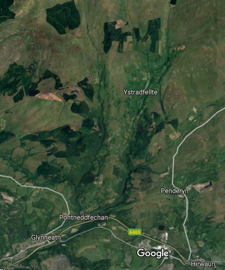
I say 'river system' because, hydrologically speaking, it's a complicated little area. The river Nedd (or 'Neath', for English speakers) rises in the foothills of the Brecon Beacons, about five kilometres north-west of Ystradfellte, and flows pretty much southwards to the pretty tourist village of Pontneddfechan. A couple of kilometres north of the village, it's augmented by the river Pyrddin, which flows in from the north-west. Meanwhile, the rivers Llia and Mellte flow more or less parallel to the Nedd before converging a short distance north of Ystradfellte. (Ignore the screaming in the background – it's just the Firefox spell checker begging for mercy.) Further east again, the river Hepste flows south-west to meet the enlarged Mellte a few kilometres south of Ystradfellte. The ever-growing Mellte hits the river Nedd at Pontneddfechan, as does the river Sychryd, which flows in from the south. From here the Nedd flows south-west towards the town of Neath (or Castell Nedd). You can trace many of these rivers on the satellite image, and it gives you an idea of the topography.
What the satellite image doesn't show you is the plethora of waterfalls in the area. Probably the most famous of these is Sgwd yr Eira, a couple of kilometres north-west of Penderyn and a fairly easy walk from the Lamb Hotel. Follow the side roads through the village, go through a metal gate and follow the gravel path around to the right until you see two wooden posts pointing you towards the waterfalls. The path leads uphill across farmland, then over open moors before dropping to the gorge of the Hepste. There's a flight of steps built into the side of the gorge, so follow them down to a rocky path just above the river.
Sgwd yr Eira is famous because the only way to get from one bank of the river to the other (unless you wade across) is to walk behind the curtain of water. I've done this numerous times, including once with a mad Labrador in tow, and I managed to kill a camera by trying to photograph the fall from within the spray. But I took a chance on Wednesday and got a couple of decent photos.
 |
| Sgwd yr Eira from the southern approach |
 |
| Sgwd yr Eira |
This wasn't my first visit to the waterfall this year. I was there on Saturday morning as well, along with about twenty or thirty people taking advantage of blue skies and warm weather. But on Wednesday I had the place to myself for once. I always feel as if I've joined Faramir and the Rangers of Gondor when I'm behind the waterfall, as I was on Saturday morning.
 |
| The view from behind Sgwd yr Eira |
The Hepste joins the Mellte about half a kilometre west of the waterfall, but there's no riverbank or footpath to take you to the confluence. Instead, there's another flight of steps which zig-zags up the slope to more open moorland. From here, I went west on well-made paths until I reached a downhill slope to Swgd y Pannwr, on the Mellte. I missed this out on Saturday as there were simply too many people enjoying the weather and the path was very crowded. But on Wednesday I had the place more or less to myself.
 |
| Sgwd y Pannwr |
From here I followed the river upstream to Sgwd Clun Gwyn Isaf. (Or Sgwd Isaf Clun Gwyn, depending on which source you're looking at.) It's not easy to get to, and I didn't venture right up to the fall as the rocks were quite slippery. But it's an impressive multi-layered fall, as you can see.
 |
| Sgwd Clun Gwyn Isaf |
Unfortunately, there isn't a direct route uphill from here, so I had to retrace my steps and climb back to the main path. It's a fairly convoluted trek along the course of the river to the final noteworthy waterfall on the Mellte, Sgwd Clun Gwyn.
As with all the falls in this area, what you'll see will depend on how much rain there's been in the previous couple of days. It's been a fairly dry March, so on Saturday the lip of the fall wasn't as wide as I've seen it on other occasions. But there were some people on the top of the drop, so you'll get an idea of the scale of the place.
 |
| Sgwd Clun Gwyn from the west |
If you continue along the river path for another kilometre or so, you'll arrive at the 'Blue Pool' and the celebrated cave at Porth yr Ogof. But if you cross the Mellte at the footbridge, you can follow it downstream on the other bank and arrive at the other side of Sgwd Clun Gwyn.
 |
| Sgwd Clun Gwyn from the east |
The path curves to the right and climbs to a gate near a farm lane. It's a short walk from here to the road from Ystradfellte to Pontneddfechan. I've walked this stretch of road several times (most recently on Saturday), but on Wednesday I tried something new. My friend Jonathan E. spends a lot of time in this area, and the last time I blogged about it he asked me if I'd ever been to Pont Melin-fach. I'd seen it signposted from various points in the Waterfall Country, but I don't think I'd ever been there before. So on Wednesday I decided to take the road less travelled. Or hardly travelled, to be more exact.
In fact, the only vehicles I saw while walking along the narrow road from Comin y Rhos were a quad bike driven by a farmer, and a Post Office van presumably delivering to the isolated farms scattered across this part of the national park. I didn't meet any other walkers either, which was a change from Saturday's hordes of visitors. After five minutes or so I passed the entrance to a farm. A short while later the winding lane crosses the bridge which gives Pont Melin-fach its name. (Pont is 'bridge' in Welsh.)
I'd arrived at the river Nedd, from where I had a rough idea where to go next. I can't be sure, but I think Mother and I have probably walked some of this stretch before. (We've explored Pontneddfechan and its surrounding area pretty thoroughly over the years.) Even so, I couldn't remember much of what I came across as I followed the Eilidr Trail downstream.
There are numerous small waterfalls on the Nedd, but the first impressive 'named' fall you come to is Swgd Ddwli Uchaf. I wasn't able to get very close to the falls on this stretch as the ground was quite treacherous in places, so I had to make the camera do the donkey work for once.
 |
| Sgwd Ddwli Isaf |
I continued to follow the river until I came to Sgwd Ddwli Isaf, a short distance downstream.
 |
| Sgwd Ddwli Isaf |
There were a few people about by now (it was early afternoon), and the Welsh weather had lived up to the old Crowded House song: Four Seasons in One Day. You might remember that we were forced to postpone last year's sponsored walk because we'd been hit by a named storm a couple of days earlier. Well, that's par for the course in this country. When I'd set off from Penderyn it was drizzling steadily. By the time I'd reached Sgwd y Pannwr we'd had a flurry of sleet; by Swgd Clun Gwyn the sun was out; when I was on the minor road the sky had definitely looked ominous, and now it was starting to rain again.
 |
| Just an average Welsh day in April |
I had no alternative but to push on to the village, but luckily it was just a heavy shower. Naturally enough, within a couple of minutes the sun was out again. I continued downstream to Sgwd y Bedol, which is in fact a rather dramatic series of waterfalls in quick succession. I'm fairly sure Mother and I had been this far, at least, as it did look very familiar.
 |
| Sgwd y Bedol |
The Nedd meets the Pyrddin soon after you pass Sgwd y Bedol (or shortly before it, depending on which direction you're walking). I crossed the Pyrddin using the footbridge and turned right, heading north-west to the final waterfall of the day: Sgwd Gwladus.
I have seen the curtain of water extending almost the full width of the shelf. But it's been oddly dry for a Welsh spring, so it was a bit of an anticlimax.
 |
| Sgwd Gwladus |
From here, you just follow the river downstream on well-made paths to arrive at Pontneddfechan. On most of my previous visits to the village I've had lunch in the Angel Inn, adjacent to the gate leading to the waterfalls. But on Saturday the place was packed, and I know their last orders for food are at 2.30. I had a couple of minutes to spare, and a board inside the door announced an hour and a half wait for meals. Instead I headed to the Old White Horse Inn, just across the river. I must say that it's going to be my regular port of call from now on. I found the staff friendlier and more welcoming than the other pub's, and the menu was about on a par. I had lunch there on Saturday, and again on Wednesday. If our sponsored walk does take us to Pontneddfechan, I'm going to suggest to the others that we make the Old White Horse our penultimate destination.
I say penultimate, because I still had to walk the kilometre or so to Pont Walby, at the bottom of the Glynneath Bank, to catch the bus back to Aberdare. But that's a small price to pay for a fourteen-kilometre walk through stunning scenery. If we can raise some cash for Anthony Nolan by retracing my journey in September, then it's definitely worth making the effort. It's an excellent walk through interesting, varied and challenging terrain and with photo opportunities galore. As John Major used to say, I commend it to the house!

No comments:
Post a Comment
If you've enjoyed this (or if you haven't), please let me know ...