In which The Author goes off the beaten track
Yesterday was a day which could have gone two ways: either the clouds were going to clear by lunchtime, or it was going to piss down. As things turned out, it went two ways anyway. Let me explain …
On Wednesday afternoon I walked the stretch of the Taff Trail from Abercynon to Pontypridd. I've done it in the opposite direction a couple of times already, most recently in 2012, when I was accompanied by Stella, the mad Labrador. I've also walked – once – from Abercynon to Merthyr, quite a few summers ago. I got slightly lost in Abercanaid, when the signs just ran out for no reason. With that in mind, I wondered whether it would be easier to head southwards instead.
Yesterday, I decided to take a chance that the weather would stay fine and headed for Merthyr on the train. I had my Philip's Street Atlas for South Wales, and the very latest edition of the Ordnance Survey 1: 25,000 Explorer map 166, covering the whole area in question. How hard could it be to go in the opposite direction? I asked myself.
Famous last words.
When I got to Merthyr I headed straight for The Works. As usual, they had a fair number of history books that I've never seen in the Aberdare branch. I didn't buy any of the ones I fancied because I had enough to carry as things stood, but I made a note of them for future reference. I walked over to Thereisnospoon, where for the second time I nearly came away empty-bellied. I tried to order a breakfast wrap, only to be told that they'd sold out. I had a flashback to the non-fish Friday with Clare a few months ago, and wondered whether to leave. Another member of staff piped up to say that they'd just taken delivery. If I waited twenty minutes, all would be well.
I parked myself at a table and started perusing the map in more detail. I knew that the Taff Trail went past Rhydycar Leisure Centre – or the 'Leisure Village', as it's now known, as it includes a cinema, a bowling alley, and all the usual US-style out of town money traps. That seemed like as a good a place as any to start from.
I didn't notice how long it took for the waiter to arrive, but I wasn't especially surprised to learn that they'd fucked up my order. For once, though, the error was in my favour. Instead of a wrap, I was going to have a full breakfast. That saved me over a quid, so I didn't say anything and tucked in.
On my way towards the bottom end of the town, I passed a charity shop. (In fact I passed about six, but that's by-the-by.) There was a slim book in the window display: Harri Webb's 1953 account of the 1831 Merthyr Rising. It was priced at just two quid. The previous day we'd marked the anniversary of that landmark event in working-class history, so I nipped in to buy it before anyone else could. However, the volunteer I spoke to wouldn't remove it from the window. She said she was afraid she'd knock something over, which made me wonder whether she's had adequate training in Manual Handling techniques.
She asked if I could wait until the manager was free. I went to browse the other books and found a copy of Evelyn Waugh's Scoop. I fancied that as well, but it was all kicking off behind me. An elderly lady, not born in the UK – I think she was speaking a Slavic language interspersed with broken English – and with obvious mental health issues to boot, was trying to leave without paying. The manager, another volunteer and two private security guards were trying to reason with/pacify/restrain her, while at the same time trying to get the police to respond to the situation. After a few minutes of this live soap opera unfolding before me, I threw the Evelyn Waugh book down and walked out.
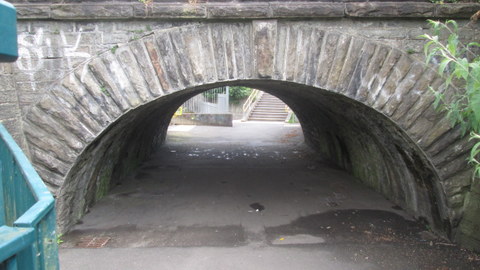
At Rhydycar, I joined the Taff Trail and headed south. I hadn't gone very far when I came to a terrific old bridge over the footpath.


I can't tell you anything about this bridge. After looking at a couple of books this morning, I'm guessing that it formed part of the original Vale of Neath Railway, which ran from Merthyr, through the famous tunnel (one mile, 737 yards) to Aberdare – to be more exact, just east of Aberdare – and thence down the Neath Valley. It's a slightly skewed arch, too, by the look of it. I'll do some more research when I'm in Merthyr Library next.
Considering that it runs through such an important area of early industry, the Taff Trail doesn't offer a great number of relics to enjoy. One notable highlight lies a little way south of the Abercanaid Industrial Estate.

This is Quay Row, a little terrace of miners' cottages which originally stood on the west bank of the Glamorganshire Canal. There's a vestige of the original waterway just in front of the gardens, but it's hard to imagine it as the main freight artery from Merthyr to Cardiff in the days before the railways.
The whole stretch as far south as Merthyr Vale is punctuated with little rows of cottages like this, in fact. As in Aberdare and the surrounding area, only their names – Pond Row, Canal Row, Furnace Row, and so forth – offer beguiling hints of the Taff Valley's past.
The surface is well made and ideal for cycling, which is why it forms part of National Cycle Network. There are a few places where traffic has access, but they're few and far between. I was able to set a decent pace as far as Pentrebach, where I left the path and headed for the Hoover/Candy factory.
Opened in 1948 on the site of the former Plymouth Ironworks, this was one of the first of the light industry employers in the Valleys. From a small start, it quickly grew in importance as the market for domestic appliances expanded. At its peak, with over five thousand people on the books, it was the main employer in the borough. When I was growing up it seemed that almost everyone I knew had at least one Hoover appliance at home. (A scurrilous rumour at the time held that a fair percentage of those had come off the back of a lorry. Certainly the factory shop must have done a roaring trade.)
Production ceased in 2009, although part of the site is still used for distribution, and last summer it was reported that the Welsh Government were negotiating to acquire the site. It's one of those buildings – especially the elevated section over the railway line which runs through the site – which will be familiar to anyone who's ever travelled along this part of the A470. I'll try and get some more photos of the derelict portion before its inevitable demolition.


The path took me straight past the tiny church of Saints Peter and Paul at Abercanaid. It's an interesting little village, with one enormous chapel, a convenience store, and some narrow terraces, dominated at the northern end by the huge Hoover building. It also has what must be one of the lowest railway underpasses in the country. Located right on the Taff, and very convenient for the train, Abercanaid looks like be a nice place to live.


I stopped at Pentrebach House (a Premier Inn) for a glass of Coke and to decide what to do next. The grand building was once, perhaps unsurprisingly, the home of Anthony Hill, one of Merthyr's nineteenth century ironmasters. Many of them – notably the Crawshay family – have a fairly bad reputation these days, but according to Merthyr Tydfil: A valley community (Merthyr Teachers Centre Group, 1981) it seems that Hill was 'well liked and respected' (op. cit., p.294) during his ownership of the Plymouth works. He was also a keen experimenter and 'involved himself in the study of the sciences on which the manufacture of iron was founded' (ibid). Renowned for its high quality, some Plymouth iron was used in the construction of Brunel's SS Great Eastern.
The clouds were starting to break up, and it was quite warm, but you should never take chances with the Welsh weather. I decided to press on as far as Merthyr Vale and play it by ear afterwards.
As I was making my way back to the station, there were three young lads playing in the grounds of the house. To my surprise, one of them shouted 'Expelliarmus!' (the disarming spell from the Harry Potter books and films) as I reached the pelican crossing. I've only recently changed my name on Facebook to 'Severus', and my screensaver is a very nice picture of Nymphadora Tonks. Coincidence? You tell me.
There isn't very much of interest in the section between Pentrebach and Troedyrhiw. (Please ignore the screaming in the background – it's just the Firefox spellchecker begging for mercy again.) There are some fine views across the valley, though. I didn't take too many photos, because I'm using Clint's old camera and I still don't know what the battery life is like. I have form in that respect, remember.
I've only been into Troedyrhiw once, many years ago, when the Cambrian had a team in the Whitbread Brewery regional pub tournament. It's on the list of places to visit for the Vanishing Valleys project, but when I'll get around to it is another story entirely.
The path continues to wind high above the valley floor, offering superb views like this.

There isn't much else to see until you arrive at the next settlement – and its name is synonymous with one of the greatest tragedies in post-war Welsh history: Aberfan.
I've been past it hundreds of times, of course, but yesterday was the first time I set foot in the village cemetery. Here, rows of spotless of white arches bear the names of over a hundred children who were killed when an unstable coal tip engulfed Pantglas Junior School, just after 9 a.m. on 21 October 1966. It's a heartbreaking experience to walk along this monument, reading not just their names – names that were fashionable at the time, and which many of my old classmates share – but also their ages: eight, nine, ten. Many of their parents now lie in the same ground, and their names are recorded here as well.
The family tributes are equally poignant, and I was especially moved by the simple description of 'Richard', the last photo in this batch. I was also touched by the sight of a young family walking slowly along the names, the children pointing out the memorials to boys and girls who were the same age as they are now. It's clear that dreadful date in our recent history will never be forgotten.


I was seven months old when the disaster happened. Like many people from the local area, Dad and some of our neighbours helped out with the attempt to rescue the victims. Even now, over fifty years on, the people of South Wales still feel angry and resentful. Not only was the catastrophe avoidable – the fund set up to aid the families of the victims (116 children, 28 adults) was raided to help pay for clearing the site. It took until 1997 for the UK government to repay the money which had been – is 'stolen' too strong a word? – and a further decade for the Welsh government to make a further payment by way of compensation. It's no wonder that just the name 'Aberfan' is enough to send a shudder through anyone my age or older, and raise a good many hackles as well.
I left this tragic tranquillity behind and rejoined the Taff rTail, now high above Merthyr Vale. It was here, in August 1989, that the last colliery in the Taff Valley closed. I took a couple of photos the following day, but they were nothing special so I won't share them with you.
A little further on, the Taff Trail turns abruptly right and uphill, before passing below the A470 in a small square tunnel. Hugging the road on its way south, the path climbs into the conifer plantations which line both sides of the slopes above the river. And then the path divided.
Up until this point, there are blue and red markers all along the route, showing you which way to go and how far you are from Cardiff, Pontypridd, Merthyr, Brecon and so forth. Suddenly, and for no obvious reason, I was faced with three alternatives and no indication as to which was the correct one. The well-made path which seemed to be the obvious option curved around to the right and climbed fairly steeply. Another well-made path dived down to the left, and looked as though it might pass under the main road at some point. Straight ahead was a rough track. Eeny meeny, miney, mo, which direction should I go? I hate multiple choice questions, even when you know a fair bit about the topic at hand. 'The Taff Trail south of Merthyr Vale' definitely wouldn't be my choice of specialist subject.
Even though the right-hand path seemed to be the obvious one, the map and street atlas were no help at all. Although the Taff Trail is marked on the OS map, even at 1:25,000 there just isn't sufficient detail for you to make out the exact route. It's also marked sporadically in the Philip's guide, but (needless to say) not south of Merthyr Vale. The left-hand path was heading towards the A470, and I didn't want to end up in the middle of a dual carriageway. I decided to go straight on.
After about a mile or so, I knew I'd chosen the wrong answer. The rough path led me up a fairly steep hill, gently downhill again, and then I came to a gate leading into an empty field. I was obviously on farmland. I had a flashback to a public footpath I took in Ystradfellte a couple of years ago, which vanished halfway through and instead led me into the back yard of a farm. Surely the same thing couldn't happen again.
I did a quick calculation. If I retraced my steps to the junction, it would take me twenty minutes or so. Then I'd have to walk for at least another twenty minutes to get as far south as I was currently, plus the rest of the way to Abercynon. The gate wasn't locked, though, and swung open easily. I decided that it was too hot for fucking about, so I pressed on.
Within a minute or so I knew I wasn't the first person to have made the same mistake. A clear line of flattened grass showed me where numerous feet had skirted the edge of the field. There was no sign of life at all, except for the birdsong and the low rumble of traffic on the main road. I had seen a vehicle parked further up the hill. It looked like a 4⨉4, which suggested that it was a farm vehicle, but it was unoccupied, and there was nobody around.
I was wondering how best to apologise to the farmer if he or she appeared from nowhere. I knew my defence was sound – the bloody signs had just vanished without any good reason – but farmers aren't normally well-disposed to townies trampling their crops. I kept thinking of the old Viz character 'Farmer Palmer', the shotgun-wielding tweed-wearing yokel with his catchphrase 'Get orff my larrnd!' Surely it was only a matter of time before I met the real McCoy.
The track around the field continued for ages. I wasn't keeping track of time, but it seemed as though I'd walked for at least a mile before it started to slope gently downwards. That was a promising sign. According to the map, at least, there was a minor road under the A470 that led to Pontygwaith, north of Quaker's Yard. Of course, with no way of knowing how far I'd walked, and with only sketchy information on my OS map, it was perfectly possible that the Pontygwaith road was the one which had branched off left from the junction, half an hour or so earlier. It's pity that the OS don't include eye-catching trees on their maps, as this one would definitely constitute a useful landmark.

At the bottom of the slope I came to something that looked like a cross between a stile and a stepladder. There was also a metal post next to it, but if it had once borne a signpost for the Taff Trail (or anywhere else), it certainly wasn't there yesterday.

I decided to quit while I was ahead, climbed over the stile-ladder, and found myself on a gravel track. At the end of it was a white van. That looked promising, at least. I carried on walking as far as a detached house with about ten cars parked outside it. There was nobody around, so I carried on walking for a few more minutes. The minor road I was on joined another minor road, running from east to west from a fairly sharp curve. I could hear the traffic clearly now, and realised that the left-hand branch would take me over the A470.
The only question was, where the fuck would I emerge?
I crossed the road and found myself in a semi-rural road lined with fairly large detached houses. It took me a few moments to find a street sign, and a little while longer to locate it on the street map. I'd somehow made my way to Goitre Coed Road, the minor thoroughfare which connects Quakers Yard to the northern end of Abercynon. A quick perusal of the street map assured me that, if I recrossed the bridge and followed the road around to the south, I'd cross the A4059 and come out in civilisation again. Well, Jenkins Street, anyway, which was a close second.
I hadn't been in that area of Abercynon since the old days of Shamrock Coaches, when they operated a really weird service which took the bus all the way to Incline Top and back through Lock Street (as far as I can remember, anyway). I only knew Lock Street by name, because my old Dillons colleague Wayne W. used to live there. But as luck would have it, I'd stumbled upon that part of the village while I was exploring it for the Cycling Project a month or so ago. I used a combination of dead reckoning, divine guidance and my unerring ability to find a pub, and about ten minutes later I was sitting in the Navigation Hotel. While I was ordering my Coke, I was intrigued by what appeared to be a pushmipullu lying behind the bar. It turned out to be two almost identical (and very friendly) fluffy white dogs lying back to back. I had them for company while I was composing the Prayer for the Taff Trail which I posted yesterday.
I caught the bus back to Aberdare, and promptly got captured by Rhian and Steff. Rhian was quite miffed that I hadn't invited her along for the day, but I hadn't known whether she was working or not. If she'd been on nights, I doubt if she'd have taken too kindly to my knocking her out of bed just after nine o'clock. I said that, if it stayed fine, we could try doing the same section in the opposite direction today. With any luck I'd be able to solve the Three Path Problem. We could even attempt Fish Friday in Thereisnospoon at the end of the walk.
I was really looking forward to it, too. Needless to say, it's been pissing down all day. I don't know when Rhian's working next, and it's anyone's guess when her day off will coincide with another suitable day for hiking. Watch this space, folks …
No comments:
Post a Comment
If you've enjoyed this (or if you haven't), please let me know ...