Showing posts with label Abercynon. Show all posts

Monday, 1 October 2018

Seventeen Miles Later ...

In which The Author and his friends go up a hill and come down a mountain
Saturday morning dawned cold and misty, and for a few moments I wondered whether I'd be taking part in the sponsored walk after all.
The night before I'd slipped at home and stubbed my right big toe hard. Very hard. In fact, it was so painful that I feared I might have broken it. Then I remembered a pub chat with Martyn E. last week. He's currently nursing a broken toe and a cracked rib – the second is the direct result of the first, which he managed to incur in work. The doctor who treated him had told him that if it had been his big toe, he wouldn't have been able to walk as his balance would have been affected. Well, I was able to walk (after a fashion), so that was a decent start.
I made my way (on foot) to Aberdare and bumped into Liam as he was coming out of the newsagent's. We made our way to the cafe near the bus station to wait for the others and had a good chat until Rhian arrived. Kate was next on the scene, with her miniature whippet Betty Boop in tow. Paul rolled up a few minutes later, and the team was complete.
Originally a few more people had expressed an interest in joining us. But Liam's parents had been doubtful from the start, as Jude injured her Achilles tendon a while ago and is recovering slowly. As they had prior commitments on Saturday, they were out anyway. Similarly, Eggy and Geraint were booked (separately) at Cwmfest, a music festival a couple of miles away in Phonicsland Cwmaman. Jason W. has had to spend the last few weekends shopping around for a new car. Alexis had something on which meant that she couldn't make it either. Anne-Marie had apparently twisted James's arm to spend the weekend in Tenby, which seemed a good call given the glorious weather. But five (plus a dog) is a nice manageable number for a first attempt like this. We were the ones who'd started Just Giving pages and collecting sponsors, after all. We boarded the 8.30 bus to Penderyn and the game was afoot.
When we arrived at the Lamb Hotel, the road was full of farm vehicles. I knew there were occasional livestock sales in the village, but I've never been to one. I must find out when the next one is happening and check it out for myself. We waited until the bus had turned around and jumped off on the return leg. It's a short walk from there to the world-renowned Penderyn Distillery, and the start of the Cynon Trail proper. I took the photos with my phone and a miniature tripod, so they aren't great, but they'll give you an idea of the sort of day we had.
Me, Rhian, Paul, Liam, Kate, Betty Boop (being carried)
The path was, until relatively recently, a freight line from the quarry opposite the Lamb to the old Hirwaun Station, and thence to the national rail network. Now it's been converted into a well-made off-road path, popular with dog walkers and horse riders as well as walkers and cyclists. It runs more or less parallel to the road, but it's far enough away that you forget about the village and just lose yourself in your surroundings. My original plan had been to lay a breadcrumb trail with Anthony Nolan stickers every so often. We had hoped for a larger number of people, of course, and I anticipated us breaking up into smaller groups as time wore on. In the event we didn't really need to place the stickers, but each one has the website address and the Walking Together logo. They might encourage casual walkers and cyclists to check out the link for themselves.
About twenty minutes into the walk, Paul commented – not for the first time – that you don't notice the distance when there aren't any landmarks. If we'd on the main road we'd have been constantly saying 'We're only as far as so-and-so', and that can get a bit disheartening.
This part of the Cynon Trail is right on the fault line between the countryside and the industrial landscape. If you look to the right as you approach Hirwaun, you can see the large opencast workings just north of the village centre. Between you and the workings there's farmland. It's an odd juxtaposition, really.
At Hirwaun we took a small detour along Elm Grove and into Station Road. Paul wanted to see the site of the old Hirwaun Football Club and the Bodwigiad Inn, which features in A Pub Crawl to Die For (Part 1). Neither of these watering holes are open for business. We followed Station Road into the centre of the village, and then our cunning plan came unstuck. We had pencilled in breakfast in the cafe, but of course Betty Boop wasn't allowed on the premises. Paul compromised by buying us all bacon rolls, which we ate on the way to the next stage of the off-road walk.
Tramway in Hirwaun is aptly named. The village plan reflects the early development of the rail network which linked the industrial centres of the Cynon Valley. There's a great old photograph showing the tramlines running along what is now a minor road through the village. When we reached the southern end of Tramway, we were off the road network again and on the route of another former tramway. This one runs behind the housing estate at Trenant, skirts the school at Rhydywaun, runs behind the huge Penywaun estate, and emerges in Trecynon. It passes some industrial archaeological sites, including the stone supports of the former Gamlyn Viaduct, the stone tramroad bridge near Gelli Isaf, and the quaint cottages at Arthurs Place. It follows the river Cynon pretty closely, and it's a beautiful sheltered stretch of the Cynon Trail. This photo in particular makes it look like an illustration from a Tolkien novel.
We hit our first problem in Penywaun. A very handsome Staffordshire bull terrier had obviously sniffed out Betty Boop's presence, as he made a beeline for her and wouldn't be dissuaded. The girls were quite shocked when I – an animal lover – suggested kicking him in the bollocks to dampen his ardour. Rhian was even more amused when I clouted him on the nose with a stick. He sprinted off in the direction he'd come from, only to catch us up a few minutes later. Kate was carrying her dog by now, but the little fellow was quite determined to follow his instincts. Eventually Paul managed to send him packing, but we kept our eyes open in case he popped up again.
We arrived at Gelli Isaf, a quaint row of cottages perched on the river's edge, and from there it's a short walk to Trecynon itself. We crossed the road and picked up the tramroad again, stopping for another photo at the historic Iron Bridge.
We continued as far as Tesco, where we took turns to look after Betty Boop while visiting the toilets. Then we were back on track, crossing the railway line into Robertstown, then crossing the Cynon near the Gadlys Arms and picking up the trail on the north side of the river. This is another well-made stretch of off-road path, emerging near the new Aberdare College building. We decided to cut out the stretch through the Ynys, and made our way past Plasdraw to the start of the Aberdare Canal nature reserve.
This isn't as grand as the name suggests, but it's a lovely stretch of the Cynon Trail, following the surviving portion of the Aberdare Canal to its end just north of Cwmbach. The flowers were still in bloom and bees and butterflies were active among the hedgerow. It was the last weekend in September, remember.
We crossed the main road and decided to wet our whistles at the Ynyscynon Inn (formerly the Golden Post). I've only been there twice in the last ten years: the first time was in December 2009, when Jenny and I went on one of our very rare dates (see A Minor Miracle); the second was with some of the Plaid Cymru Cwm Cynon gang when we leafleted the whole of Cwmbach in one day. It's not a pub that regularly features on my radar because it's on the wrong side of Aberdare. But the sun was over the yardarm and it seemed rude to just walk past without calling in.
It was obvious that our little dog was running out of steam, and Kate came up with a good idea. If we took the short cut from the new housing estate to Pant Farm, we could follow the old Vale of Neath line to Blaennantygroes, drop Betty Boop off at Kate's grandmother's house, and then drop down to the village shop. It would cut out the gradual (but very exposed) climb through Cwmbach and give us a nice shady alternative. So that was what we did.
I don't know the new part of Cwmbach very well, but Kate used to have a paper round in the village. That sort of local knowledge can't be beaten when it comes to finding short cuts and alternative routes on the fly. We slipped through a small alleyway between two houses, made our way uphill through Pant Farm, and climbed the embankment leading to the old railway line. There's a stunning old tunnel there, which I need to photograph properly when I get the chance. And then we were on the Vale of Neath path. The footpath leads to the former Merthyr Tunnel, but it also forks and drops down to the top of Blaennantygroes.
Liam was definitely setting the pace, with the girls following on and Paul and I bringing up the rear. We had a good laugh when we encountered another fallen tree, which would have probably rendered the path 'impassable' on health and safety grounds if the little dog hadn't been able to just spring over it.
We branched off into Blaennantygroes, dropped Betty Boop off, and continued downhill to the shop. It's a short walk uphill to the Royal Oak, which had crossed our minds for another stop. But I wasn't sure whether the Cefnpennar Inn would be open, so I'd persuaded the gang to push on as far as that. We made our way up the tarmac part of Cefnpennar Road, where I think Paul was starting to struggle a bit. We made it as far as the entrance to Llettyshenkin House, and then hit the most challenging part of the route so far.
I've already shown you what Cefnpennar Road is like, but here's a photo I took on Friday morning. It's a road in the very loosest sense of the word. Some of my older friends have called it 'the parish road', which suggests that it was a main thoroughfare in bygone days. It certainly isn't one now.
Paul and I made it to the top a few minutes after the others, and we all decided to have a breather in the field. The views from here made the whole ascent worthwhile, but by now my battery was running low. I took one photo of us and we continued on our way.
The descent into Cefnpennar village was fairly uneventful, with Liam continuing to set the pace. As such he reached the pub before the rest of us – and it was closed. I'd had a feeling that that would be the case, so I wasn't all that surprised. But we were a bit disappointed all the same. We continued downhill through the village, with Liam charging ahead of us. We weren't sure if he was setting the pace, or simply being carried forward by the weight of his backpack. By the time we passed the entrance to the golf course he was way in front and picking up speed on the descent into Cwmpennar.
I turned to the others and said, 'Liam's broken into a sprint. Or else he's just broken.'
When we got to Cwmpennar we found out why he'd had that burst of energy. There's a bench at the side of the road. We had a little breather there, then continued to Duffryn Woods and spent a few minutes admiring Prof. James Havard Thomas's magnificent war memorial, which stands in a little clearing surrounded by trees on all sides. You can almost picture yourself in Flanders when you see it from this angle.
We stopped at the indoor bowls centre to use the toilets, then continued past the Aberdare Hotel and Mountain Ash Town Hall to pick up the Cynon Trail beside Nazareth Baptist Church. After following the river for five minutes or so, we arrived opposite our next scheduled stop: the George.
This is a rather odd little pub in Newtown, Mountain Ash. I've been there a few times and the people at the bar have always made it perfectly clear that it's a local pub for local people. But Paul knows everyone, and one of his pals was sitting outside when we arrived. We ordered our drinks and waited while the landlord set up a table and chairs outside for us. There was a diversion in effect on that stretch of the Cynon Trail, so we knew we'd have to continue along Old Cardiff Road and past Usk Villas to pick it up further south. By now the effects of the long slog over Cefnpennar Road were taking their toll. I think a couple of us were tempted to call it a day and catch the first bus back to Aberdare. But Paul, in fairness, was committed to walking the entire distance. I was still raring to go, so we talked about it over our drinks and decided to push on.
There's a new road being built across the valley just south of Mountain Ash, which accounted for the closure of the Cynon Trail. It was one of the main reasons why I abandoned our Arthur Linton Challenge cycling project for this year. It made for an 'interesting' diversion from the route I'd originally drawn up. There's a flight of steps up to the new road from Usk Villas, and Rhian was really starting to struggle during the ascent. Liam, as usual, was powering ahead of the rest of us. Paul and Kate were going to follow the A4059 to begin with until I called them back. It could have all gone wrong at this point. Can you imagine trying to co-ordinate a large number of cyclists around this section? I certainly can't. With any luck it'll be finished by next summer and I can have a second attempt at making the project come to fruition.
There isn't a great deal left of the industrial sites south of Mountain Ash. The pits were pulled down once they closed, and the railway sidings have vanished as well. The Cynon Trail winds along parallel to the river, sheltered by trees for most of its length, and without any real landmarks to tell you how far you've walked. I've walked this part at least four times in the last year while drawing up the Arthur Linton Challenge so I knew where we were, but it didn't really matter. Once we reached the Pontcynon Industrial Estate, my plans to lay a breadcrumb trail fell apart.
Rhian was lagging behind us. Kate was charging ahead to use the toilet at Abercynon Sports Centre. Paul, Liam and I got as far the sports centre, sat down to wait for Kate, and then waited ages for Rhian to come into view. It did cross our minds that she might have stopped at Abercynon Rugby Club, just off the Quarter Mile Bridge. I rang her, only to find that she'd crossed the bridge and was walking along the Old Road. In fact, she'd overtaken us and was passing Abercynon Library at the time. We grabbed our gear and set off along the final section of the route. We came out into River Row, crossed the Cynon and followed the road towards the fire station.
There's a signpost at the end of Greenfield Terrace advising you that it's 14.5 miles to Cardiff.
I pointed at it and said, 'Who's up for pushing on to Pontypridd?'
(That's the furthest point at which our Day Rider tickets would still have been valid.)
Liam gave me a murderous look, so I scrapped that idea and we headed for the Navigation Hotel, our original finishing point. Rhian was emerging with a pint when we arrived, so we grabbed a table outside and settled down to wait for the bus home. The whole adventure had taken us just over eight hours, and by that time we were all ready for a sit down and a nice cold drink.
Kate's expression might be the laughter of hysterical madness. Liam is definitely not amused. The rest of are putting on brave faces.
We caught a bus back to Aberdare at just before 6.00. Paul jumped off at Asda, from where he could cross into Aberaman near his house. Liam crawled off to get a taxi home, which is almost unheard of. Kate had to run home to change for her evening shift in Jacs. Rhian hobbled as far as the Lucky Star with me, and then hobbled up the hill to Jacs with me. For some bizarre reason I was still feeling fine. Maybe it's because I'd walked about half of the route in the previous week, scoping out the extent of the storm damage. Maybe I'm fitter than I thought. Kate seemed to have got her second wind, but I decided to bale out on the 10.30 bus. The walk up to Trecynon could have been the last straw for me.
In spite of the aches, pains, diversions, horny dogs, cock-ups, and assorted niggles en route, we all had a brilliant time. We couldn't have had a better day weather-wise, and of course it's a fantastic way to raise money for Anthony Nolan. We've all decided that Walking Together from Jacs should definitely become an annual event. Every year it'll be a different route, always ending at a convivial pub for a bite to eat. We'll know the potential pitfalls next time, and can plan around them.
For my part, I've hit my £250 fundraising target. Some very generous online donations took my Just Giving total over the halfway point on Thursday. I've got to catch up with a few people who sponsored me the old-fashioned way, but I'm well pleased with the result. I don't how the others have done, as they were mostly collecting sponsors on paper as well. I'll let you the full amount when it's all paid in. In the meantime we're going to leave the Just Giving page open for a couple of weeks, in case anyone wants to chip in retrospectively. All in all it was a great way to round off a summer of friendship and fun in Jacs, and the perfect taster session for the regular event starting next year. Why not join us next time?

Friday, 17 August 2018

Get on Your Boots

In which The Author is planning a sponsored walk
I can't believe it's been nearly four months since I last posted anything. There are a couple of reasons for that, and neither of them are any cause for concern.
Primarily, I've been copy-editing and/or proofreading pretty much non-stop since the middle of November. The first half of the year saw me go from book to book with hardly a break, and things only slowed down because it was the start of everyone's holidays. They're obviously over, because in the past month I've proofread two historical novels, copy-edited a novella by Ben Aaronovitch, and I've just sent Peter Higgins' new fantasy novel back to Gollancz.
The other reason is that I've become more involved with Jacs Music Venue here in Aberdare. Between helping with the publicity side of things, writing content for their new website, and researching the history of Bryngolwg House in my rare periods of down time, it's become my second home at weekends.
The Blowout boys (Mitch and Connor) have done us proud in the last few months, bringing the lunacy of John Otway and the brilliance of Space to our little town. We've got Electric Six – an actual American touring band – headlining next Friday night. (Don't bother looking for the ticket link; it sold out within a couple of days.) In October, the wonderful Neil Innes is paying us a visit. I'm selling tickets for that one, if anyone is interested.
As well as the Blowout gigs, we're going from strength to strength in our own right. Despite my best efforts I wasn't able to persuade Caravan to take a punt on a Welsh gig, unfortunately. On the other hand, Fairport Convention are definitely interested. So is Mike Peters, the driving force behind the Welsh post-punk legends the Alarm. And the blue-eyed boys of Scottish soul, Hue and Cry, are visiting us in February. (That isn't one of mine, but I'll plug it anyway.)
My own Anthony Nolan fundraising gig at Jacs fell foul of double-bookings, festivals, and – the bane of every rock promoter – general Aberdare apathy. However, the comedy writers Rob Grant and Andrew Marshall very generously signed a brand new copy of their novel The Quanderhorn Xperimentations, which we raffled during the gig. That, along with donations on the night and in the ensuing couple of days, took our total to £142. Many thanks to Lazarus Moon, Windshake, Adelade, Black Aurora and Chris Noir for coming along and showcasing their fine music – even if it was pretty much to each other. We'll be doing another next year, and this time it'll all go according to plan.
We had a very successful gig last Saturday, when Steve Ignorant's Slice of Life headlined an evening of post-punk political music. Steve's previous visit to Aberdare (11 July 1984) was the last time the full Crass line-up shared a stage, at a miners' benefit gig in the Coliseum. He'd gone on record a while back saying that he'd love to return to the town where Crass ended their days as a performing outfit. A few of us cast the bait in his direction, and after a flurry of emails, he and I we able to sort out a date.
It was a pretty emotional evening for us all, but nobody more so than the man himself. We had a chat over a pint before the rest of the band arrived, and he was really thrilled to be playing here after all that time. In fact, he's asked if he can come back next year. Well, we're hardly likely to say no, are we?
I also managed to cast the bait out to Doctor and the Medics a couple of months ago, when I messaged the Doctor himself on Twitter. They're coming here in October, as part of our pre-Halloween fancy dress extravaganza. I've got a couple more irons in the fire as well, but more on that story later.
The sad news is that the Arthur Linton Challenge isn't going ahead this year, in spite of all my planning. The construction of the new road in Mountain Ash is causing so much disruption that it seems hardly worth trying to pin down a route. But in the absence of a cycling marathon (a velothon, in fact) some of us are planning a rather more sedate way to explore the valley.
September is Walking Together month for Anthony Nolan. As a result of exploring pretty much every footpath in the Cynon Valley while drawing up the Arthur Linton Challenge, I've been able to come up with the perfect way to get from Penderyn to Abercynon and fall a whisker short of 25 km. For the most part we're going to utilise the Cynon Trail, route 478 of the National Cycle Network. Because it's largely made up of disused railway lines and dedicated traffic-free rights of way, we'll be on the level for most of the distance. It'll cost each of us £5.20 for a Day Rider ticket on Stagecoach, which will get us to Penderyn for the start, and back from Abercynon at the end. If anyone feels that they can't manage the whole distance, the same ticket will get them safely home again. It sounds like a decent plan, doesn't it?
Starting from the Lamb Hotel at the southern edge of the Brecon Beacons, we'll take the old Mineral Line (a disused freight railway) into Hirwaun. From there we'll pick up the old tramway, which runs more or less alongside the river Cynon. After passing the historic iron bridge in Trecynon, we'll cross into Robertstown. I think there might be a refreshment stop at the Gadlys Arms, but that'll depend on how everyone's feeling.
We'll pick up the Cynon Trail on the other side of the river, and continue along the river to the new college. From there we'll cut across into the Ynys, and walk around the playing fields before arriving at the remaining stretch of the Aberdare Canal. This takes us to the A4059 at Cwmbach, where we'll leave the Cynon Trail for a little while.
The Cynon Trail proper follows the A4059 past Ysbyty Cwm Cynon, Mountain Ash School and the indoor bowls centre before reaching Mountain Ash itself. It's a horrible stretch of fast road, with heavy traffic, nothing exciting to see, and at best it's a necessary evil on a bike. We'll be on foot. It's no fun at all on foot.
While I was scoping out alternatives to this section for the Arthur Linton Challenge, I came up with a cunning plan. And that, slightly altered and reversed, is where we are going to go next.
From the Ynyscynon Inn (another possible refreshment stop) we'll head into the village of Cwmbach. It's a steady gentle ascent to the post office, where we'll veer off into Cefnpennar Road. Then the fun really starts.
I wasn't sure if the eastern section of Cefnpennar Road even was a right of way until I consulted some old friends. Geoff told me that he used to walk that footpath regularly when he was younger, but he hadn't been there for a long time. Luckily Mark W. lives in Cwmbach and spends a lot of time walking the hillsides around the village. He told me that it was possible to go over the top into Cefnpennar, but it wasn't a journey for the faint-hearted. On 1 September last year I caught a bus to Cwmbach, jumped off by the post office, and went on what councillors call a 'site visit'.
Have a look and tell me what you think of this right of way.
Intriguing, isn't it?
Anyway, that's the start of the ascent from Cwmbach to Cefnpennar. It's what you'll find if you continue past the Cottage Homes and the pedestrian lane into Bryn Hir. It's actually got a name (Cefnpennar Road), and it's marked on the Ordnance Survey maps and the Philip's Street Atlas as a right of way. As you can see from the sign, it isn't open to traffic. It's probably a good thing.
Who on earth would want to drive along here?
I came to this point and wondered if Mark had been pulling my leg. There was no sign of life, no 'right of way' markers, and the upward path seemed fairly rudimentary. But I started walking, wondering if anyone would be crazy enough to risk cycling this way. At least they'd be going downhill, if my plan went ahead. But would you want to cycle on terrain like this?
That's about as good as it gets, in fact. Further up it was like a river bed on an incline, with quite a bit of water running downhill. I'd been wondering if I really was going the right way when I saw a lady with two dogs coming towards me. She told me that the path levels out a little further on, and then cuts across a field to emerge at the top of Cefnpennar. I carried on for another couple of minutes, found the gate to the field, and then knew that the whole mission had been worthwhile. Look at the view from the top.
Aberdare Community School is more or less in the centre

Looking back towards Cwmbach and Aberdare

Looking across towards Mountain Ash
It's well worth making the effort, isn't it?
My friend Lee J. lived in Bryn Hir when we were in school, and he often used to tell me how he and his pals would go exploring by 'the mast' in Cwmbach. It's clearly visible from the northern half of the valley, but I was surprised to learn that Cefnpennar Road skirts right past it.
From here, it's a fairly steady descent into Cefnpennar itself. It was surprisingly mild for the time of year, and I fancied a pint when I arrived at the centre of the village. No such luck; the pub was closed, and there was no sign of its being open during the evenings either. But it did provide me with yet another photo for my collection of the old Aberdare Local Board of Health street name plates. I'd always assumed that Cefnpennar would have been in Mountain Ash, but apparently not.
The main street itself feels as though it belongs in the Yorkshire Dales, rather than above a former mining valley in South Wales. It's a rather odd little settlement, all told.
I walked to Cwmpennar, a little further down the hill, and then a bus came along. I decided to jump on, and we went on a magical mystery tour of Caegarw and Newtown before eventually arriving in Mountain Ash itself.
We'll be on foot, of course. If the Cefnpennar Inn isn't open we can walk down into Caegarw and have a cheeky livener at the indoor bowls centre. The Cynon Trail goes off-road again opposite the centre, so it's the ideal place to rejoin the path.
It passes underneath Mountain Ash Bridge, skirts the river as far as the George Hotel (another possible refreshment stop), and then weaves its way between the A4059 and the river Cynon as far as Pontcynon Industrial Estate. We'll be back on the road briefly, as far as the Quarter Mile Bridge, then the path drops past Abercynon Sports Centre and follows the railway line south, emerging at the end of River Row. It's a short walk from there to the Navigation Inn, and the end of our journey.
I've used the plural pronoun throughout because it's called 'Walking Together' for a reason. The whole idea behind the fundraising project is to get people out in groups, so I've been putting some feelers out. So far I've managed to recruit Rhian, Geraint and Jonathan from Dapper FM, Clint and Ros (our resident gig photographers), Gavin and Kate from Jacs, and Jude, Andrew and Liam, who are all keen walkers as a family. Jason W. said he was interested, depending on the date; Rebecca and Lee might come if they haven't got a gig; Alexis and Kevin are checking their diaries as well.
The last weekend in September is Cwmfest, so that's out for starters. We've got a big charity gig in Jacs on 1 September, so we can rule that out as well. It looks as though the optimum date for everyone is 22 September. We'll be looking for sponsors in the old-fashioned way, with pen and paper, but we're also doing the high-tech alternative via JustGiving. We'll each have our own page linked to the Walking Together event. Here's mine, if you fancy chipping for a very worthwhile cause.
If you live too far afield to join us on the day, why not round up some friends and organise something similar in your own area? Go to the Anthony Nolan website and you can sign up for a fundraising pack. It's going to be a great way to get some exercise and fresh air, make new friends, and explore your community in more detail. Go on, you know you want to!

Friday, 2 June 2017

On and Off the Trail

In which The Author goes off the beaten track
Yesterday was a day which could have gone two ways: either the clouds were going to clear by lunchtime, or it was going to piss down. As things turned out, it went two ways anyway. Let me explain …
On Wednesday afternoon I walked the stretch of the Taff Trail from Abercynon to Pontypridd. I've done it in the opposite direction a couple of times already, most recently in 2012, when I was accompanied by Stella, the mad Labrador. I've also walked – once – from Abercynon to Merthyr, quite a few summers ago. I got slightly lost in Abercanaid, when the signs just ran out for no reason. With that in mind, I wondered whether it would be easier to head southwards instead.
Yesterday, I decided to take a chance that the weather would stay fine and headed for Merthyr on the train. I had my Philip's Street Atlas for South Wales, and the very latest edition of the Ordnance Survey 1: 25,000 Explorer map 166, covering the whole area in question. How hard could it be to go in the opposite direction? I asked myself.
Famous last words.
When I got to Merthyr I headed straight for The Works. As usual, they had a fair number of history books that I've never seen in the Aberdare branch. I didn't buy any of the ones I fancied because I had enough to carry as things stood, but I made a note of them for future reference. I walked over to Thereisnospoon, where for the second time I nearly came away empty-bellied. I tried to order a breakfast wrap, only to be told that they'd sold out. I had a flashback to the non-fish Friday with Clare a few months ago, and wondered whether to leave. Another member of staff piped up to say that they'd just taken delivery. If I waited twenty minutes, all would be well.
I parked myself at a table and started perusing the map in more detail. I knew that the Taff Trail went past Rhydycar Leisure Centre – or the 'Leisure Village', as it's now known, as it includes a cinema, a bowling alley, and all the usual US-style out of town money traps. That seemed like as a good a place as any to start from.
I didn't notice how long it took for the waiter to arrive, but I wasn't especially surprised to learn that they'd fucked up my order. For once, though, the error was in my favour. Instead of a wrap, I was going to have a full breakfast. That saved me over a quid, so I didn't say anything and tucked in.
On my way towards the bottom end of the town, I passed a charity shop. (In fact I passed about six, but that's by-the-by.) There was a slim book in the window display: Harri Webb's 1953 account of the 1831 Merthyr Rising. It was priced at just two quid. The previous day we'd marked the anniversary of that landmark event in working-class history, so I nipped in to buy it before anyone else could. However, the volunteer I spoke to wouldn't remove it from the window. She said she was afraid she'd knock something over, which made me wonder whether she's had adequate training in Manual Handling techniques.
She asked if I could wait until the manager was free. I went to browse the other books and found a copy of Evelyn Waugh's Scoop. I fancied that as well, but it was all kicking off behind me. An elderly lady, not born in the UK – I think she was speaking a Slavic language interspersed with broken English – and with obvious mental health issues to boot, was trying to leave without paying. The manager, another volunteer and two private security guards were trying to reason with/pacify/restrain her, while at the same time trying to get the police to respond to the situation. After a few minutes of this live soap opera unfolding before me, I threw the Evelyn Waugh book down and walked out.
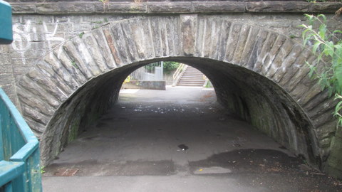
At Rhydycar, I joined the Taff Trail and headed south. I hadn't gone very far when I came to a terrific old bridge over the footpath.
I can't tell you anything about this bridge. After looking at a couple of books this morning, I'm guessing that it formed part of the original Vale of Neath Railway, which ran from Merthyr, through the famous tunnel (one mile, 737 yards) to Aberdare – to be more exact, just east of Aberdare – and thence down the Neath Valley. It's a slightly skewed arch, too, by the look of it. I'll do some more research when I'm in Merthyr Library next.
Considering that it runs through such an important area of early industry, the Taff Trail doesn't offer a great number of relics to enjoy. One notable highlight lies a little way south of the Abercanaid Industrial Estate.
This is Quay Row, a little terrace of miners' cottages which originally stood on the west bank of the Glamorganshire Canal. There's a vestige of the original waterway just in front of the gardens, but it's hard to imagine it as the main freight artery from Merthyr to Cardiff in the days before the railways.
The whole stretch as far south as Merthyr Vale is punctuated with little rows of cottages like this, in fact. As in Aberdare and the surrounding area, only their names – Pond Row, Canal Row, Furnace Row, and so forth – offer beguiling hints of the Taff Valley's past.
The surface is well made and ideal for cycling, which is why it forms part of National Cycle Network. There are a few places where traffic has access, but they're few and far between. I was able to set a decent pace as far as Pentrebach, where I left the path and headed for the Hoover/Candy factory.
Opened in 1948 on the site of the former Plymouth Ironworks, this was one of the first of the light industry employers in the Valleys. From a small start, it quickly grew in importance as the market for domestic appliances expanded. At its peak, with over five thousand people on the books, it was the main employer in the borough. When I was growing up it seemed that almost everyone I knew had at least one Hoover appliance at home. (A scurrilous rumour at the time held that a fair percentage of those had come off the back of a lorry. Certainly the factory shop must have done a roaring trade.)
Production ceased in 2009, although part of the site is still used for distribution, and last summer it was reported that the Welsh Government were negotiating to acquire the site. It's one of those buildings – especially the elevated section over the railway line which runs through the site – which will be familiar to anyone who's ever travelled along this part of the A470. I'll try and get some more photos of the derelict portion before its inevitable demolition.
The path took me straight past the tiny church of Saints Peter and Paul at Abercanaid. It's an interesting little village, with one enormous chapel, a convenience store, and some narrow terraces, dominated at the northern end by the huge Hoover building. It also has what must be one of the lowest railway underpasses in the country. Located right on the Taff, and very convenient for the train, Abercanaid looks like be a nice place to live.


I stopped at Pentrebach House (a Premier Inn) for a glass of Coke and to decide what to do next. The grand building was once, perhaps unsurprisingly, the home of Anthony Hill, one of Merthyr's nineteenth century ironmasters. Many of them – notably the Crawshay family – have a fairly bad reputation these days, but according to Merthyr Tydfil: A valley community (Merthyr Teachers Centre Group, 1981) it seems that Hill was 'well liked and respected' (op. cit., p.294) during his ownership of the Plymouth works. He was also a keen experimenter and 'involved himself in the study of the sciences on which the manufacture of iron was founded' (ibid). Renowned for its high quality, some Plymouth iron was used in the construction of Brunel's SS Great Eastern.
The clouds were starting to break up, and it was quite warm, but you should never take chances with the Welsh weather. I decided to press on as far as Merthyr Vale and play it by ear afterwards.
As I was making my way back to the station, there were three young lads playing in the grounds of the house. To my surprise, one of them shouted 'Expelliarmus!' (the disarming spell from the Harry Potter books and films) as I reached the pelican crossing. I've only recently changed my name on Facebook to 'Severus', and my screensaver is a very nice picture of Nymphadora Tonks. Coincidence? You tell me.
There isn't very much of interest in the section between Pentrebach and Troedyrhiw. (Please ignore the screaming in the background – it's just the Firefox spellchecker begging for mercy again.) There are some fine views across the valley, though. I didn't take too many photos, because I'm using Clint's old camera and I still don't know what the battery life is like. I have form in that respect, remember.
I've only been into Troedyrhiw once, many years ago, when the Cambrian had a team in the Whitbread Brewery regional pub tournament. It's on the list of places to visit for the Vanishing Valleys project, but when I'll get around to it is another story entirely.
The path continues to wind high above the valley floor, offering superb views like this.
There isn't much else to see until you arrive at the next settlement – and its name is synonymous with one of the greatest tragedies in post-war Welsh history: Aberfan.
I've been past it hundreds of times, of course, but yesterday was the first time I set foot in the village cemetery. Here, rows of spotless of white arches bear the names of over a hundred children who were killed when an unstable coal tip engulfed Pantglas Junior School, just after 9 a.m. on 21 October 1966. It's a heartbreaking experience to walk along this monument, reading not just their names – names that were fashionable at the time, and which many of my old classmates share – but also their ages: eight, nine, ten. Many of their parents now lie in the same ground, and their names are recorded here as well.
The family tributes are equally poignant, and I was especially moved by the simple description of 'Richard', the last photo in this batch. I was also touched by the sight of a young family walking slowly along the names, the children pointing out the memorials to boys and girls who were the same age as they are now. It's clear that dreadful date in our recent history will never be forgotten.
I was seven months old when the disaster happened. Like many people from the local area, Dad and some of our neighbours helped out with the attempt to rescue the victims. Even now, over fifty years on, the people of South Wales still feel angry and resentful. Not only was the catastrophe avoidable – the fund set up to aid the families of the victims (116 children, 28 adults) was raided to help pay for clearing the site. It took until 1997 for the UK government to repay the money which had been – is 'stolen' too strong a word? – and a further decade for the Welsh government to make a further payment by way of compensation. It's no wonder that just the name 'Aberfan' is enough to send a shudder through anyone my age or older, and raise a good many hackles as well.
I left this tragic tranquillity behind and rejoined the Taff rTail, now high above Merthyr Vale. It was here, in August 1989, that the last colliery in the Taff Valley closed. I took a couple of photos the following day, but they were nothing special so I won't share them with you.
A little further on, the Taff Trail turns abruptly right and uphill, before passing below the A470 in a small square tunnel. Hugging the road on its way south, the path climbs into the conifer plantations which line both sides of the slopes above the river. And then the path divided.
Up until this point, there are blue and red markers all along the route, showing you which way to go and how far you are from Cardiff, Pontypridd, Merthyr, Brecon and so forth. Suddenly, and for no obvious reason, I was faced with three alternatives and no indication as to which was the correct one. The well-made path which seemed to be the obvious option curved around to the right and climbed fairly steeply. Another well-made path dived down to the left, and looked as though it might pass under the main road at some point. Straight ahead was a rough track. Eeny meeny, miney, mo, which direction should I go? I hate multiple choice questions, even when you know a fair bit about the topic at hand. 'The Taff Trail south of Merthyr Vale' definitely wouldn't be my choice of specialist subject.
Even though the right-hand path seemed to be the obvious one, the map and street atlas were no help at all. Although the Taff Trail is marked on the OS map, even at 1:25,000 there just isn't sufficient detail for you to make out the exact route. It's also marked sporadically in the Philip's guide, but (needless to say) not south of Merthyr Vale. The left-hand path was heading towards the A470, and I didn't want to end up in the middle of a dual carriageway. I decided to go straight on.
After about a mile or so, I knew I'd chosen the wrong answer. The rough path led me up a fairly steep hill, gently downhill again, and then I came to a gate leading into an empty field. I was obviously on farmland. I had a flashback to a public footpath I took in Ystradfellte a couple of years ago, which vanished halfway through and instead led me into the back yard of a farm. Surely the same thing couldn't happen again.
I did a quick calculation. If I retraced my steps to the junction, it would take me twenty minutes or so. Then I'd have to walk for at least another twenty minutes to get as far south as I was currently, plus the rest of the way to Abercynon. The gate wasn't locked, though, and swung open easily. I decided that it was too hot for fucking about, so I pressed on.
Within a minute or so I knew I wasn't the first person to have made the same mistake. A clear line of flattened grass showed me where numerous feet had skirted the edge of the field. There was no sign of life at all, except for the birdsong and the low rumble of traffic on the main road.  I had seen a vehicle parked further up the hill. It looked like a 4⨉4, which suggested that it was a farm vehicle, but it was unoccupied, and there was nobody around.
I was wondering how best to apologise to the farmer if he or she appeared from nowhere. I knew my defence was sound – the bloody signs had just vanished without any good reason – but farmers aren't normally well-disposed to townies trampling their crops. I kept thinking of the old Viz character 'Farmer Palmer', the shotgun-wielding tweed-wearing yokel with his catchphrase 'Get orff my larrnd!' Surely it was only a matter of time before I met the real McCoy.
The track around the field continued for ages. I wasn't keeping track of time, but it seemed as though I'd walked for at least a mile before it started to slope gently downwards. That was a promising sign. According to the map, at least, there was a minor road under the A470 that led to Pontygwaith, north of Quaker's Yard. Of course, with no way of knowing how far I'd walked, and with only sketchy information on my OS map, it was perfectly possible that the Pontygwaith road was the one which had branched off left from the junction, half an hour or so earlier. It's pity that the OS don't include eye-catching trees on their maps, as this one would definitely constitute a useful landmark.
At the bottom of the slope I came to something that looked like a cross between a stile and a stepladder. There was also a metal post next to it, but if it had once borne a signpost for the Taff Trail (or anywhere else), it certainly wasn't there yesterday.
I decided to quit while I was ahead, climbed over the stile-ladder, and found myself on a gravel track. At the end of it was a white van. That looked promising, at least. I carried on walking as far as a detached house with about ten cars parked outside it. There was nobody around, so I carried on walking for a few more minutes. The minor road I was on joined another minor road, running from east to west from a fairly sharp curve. I could hear the traffic clearly now, and realised that the left-hand branch would take me over the A470.
The only question was, where the fuck would I emerge?
I crossed the road and found myself in a semi-rural road lined with fairly large detached houses. It took me a few moments to find a street sign, and a little while longer to locate it on the street map. I'd somehow made my way to Goitre Coed Road, the minor thoroughfare which connects Quakers Yard to the northern end of Abercynon. A quick perusal of the street map assured me that, if I recrossed the bridge and followed the road around to the south, I'd cross the A4059 and come out in civilisation again. Well, Jenkins Street, anyway, which was a close second.
I hadn't been in that area of Abercynon since the old days of Shamrock Coaches, when they operated a really weird service which took the bus all the way to Incline Top and back through Lock Street (as far as I can remember, anyway). I only knew Lock Street by name, because my old Dillons colleague Wayne W. used to live there. But as luck would have it, I'd stumbled upon that part of the village while I was exploring it for the Cycling Project a month or so ago. I used a combination of dead reckoning, divine guidance and my unerring ability to find a pub, and about ten minutes later I was sitting in the Navigation Hotel. While I was ordering my Coke, I was intrigued by what appeared to be a pushmipullu lying behind the bar. It turned out to be two almost identical (and very friendly) fluffy white dogs lying back to back. I had them for company while I was composing the Prayer for the Taff Trail which I posted yesterday.
I caught the bus back to Aberdare, and promptly got captured by Rhian and Steff. Rhian was quite miffed that I hadn't invited her along for the day, but I hadn't known whether she was working or not. If she'd been on nights, I doubt if she'd have taken too kindly to my knocking her out of bed just after nine o'clock. I said that, if it stayed fine, we could try doing the same section in the opposite direction today. With any luck I'd be able to solve the Three Path Problem. We could even attempt Fish Friday in Thereisnospoon at the end of the walk.
I was really looking forward to it, too. Needless to say, it's been pissing down all day. I don't know when Rhian's working next, and it's anyone's guess when her day off will coincide with another suitable day for hiking. Watch this space, folks …